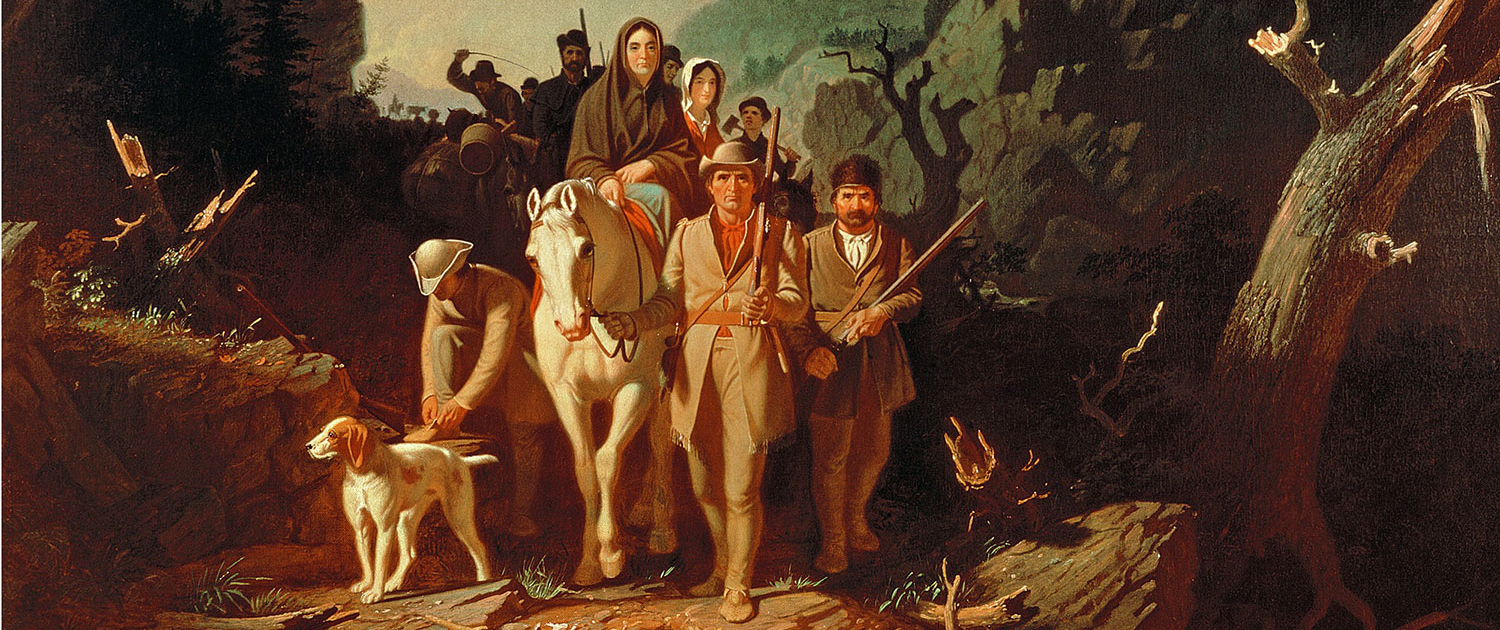
Historical Rendering of Daniel Boone Along the Wilderness Road
One of the nation’s most historic routes, the Daniel Boone Wilderness Trail was blazed by the legendary frontiersman in 1775 from the Long Island of the Holston at what is now Kingsport TN, through the Cumberland Gap of Virginia into Kentucky. It would become the route for thousands of settlers to the western frontier.
Long before Columbus discovered America, the Wilderness Trail was a major link in the trail systems of the Indians on the North American continent, used for commerce and raids. Gabriel Arthur, a young indentured servant, was the first of record to travel the route and see the Cumberland Gap, a natural break in the mountains. Arthur was sent along the trail in 1674 by the Shawnee Indians to secure a trade agreement with settlers. The next recorded man to see the Gap was Dr. Thomas Walker in 1750.
The most daring effort to colonize the rich lands of the Kentucky River area were those of Colonel Richard Henderson, a Superior Court judge of North Carolina. Henderson decided the best way to secure the area was to deal directly with the Cherokee Indians. He discussed plans with friends, and they formed the Transylvania Company and solicited the assistance of Boone in negotiating with the Indians and blazing the trail.
On March 10, 1775, Boone led his 30 trail blazers from Long Island of the Holston to cut the trail through some 200 miles of wilderness northwest through the Cumberland Gap and into Kentucky.
Thanks to the Daniel Boone Wilderness Road Trail Association, today, travelers can follow the Wilderness Trail as closely as possible along the original route. Several historical stops are available along the route, and it makes a great day-long road trip through the scenic rolling hills and valleys of Scott County, VA into Lee County, VA to the Cumberland Gap into Kentucky.
Travelers may begin their journey at any juncture along the Wilderness Road. Some of the more significant stops are listed below. For detailed map: https://danielboonetrail.com/trail-map/
Netherland Inn, Long Island of the Holston, Kingsport, Tennessee
Long Island on the Holston, or Hogoheegee River was the sacred treaty ground to the Cherokee. It is the western terminus of the Reedy Creek Road, which carried the Great Warrior’s Path from Bristol to Kingsport. The Netherland Inn was strategically located in King’s Port and served as a way station for both river and road travelers. Visitors can access the Long Island of the Holston via a swinging bridge, located on the Greenbelt walkway across from the Netherland Inn. On the island, visitors can see the monument erected by the Cherokee nation on land ceded to them in commemoration of the United States Bicentennial. The stone in the monument was brought from the Qualla Reservation at Cherokee, North Carolina.
Cherokee Nation Marker at Long Island of the Holston
Anderson Blockhouse Site, Carters Valley, Scott County, Virginia
The historic marker indicates the original location of the John Anderson Blockhouse. Anderson built his blockhouse on the knoll here sometime before 1775. (A replica of the John Anderson Blockhouse was constructed at Natural Tunnel State Park, Duffield, VA. Generally open Saturday and Sunday, May through October, it is currently closed due to COVID-19. Visitors can drive up and visit the grounds.)
A blockhouse was a specialized log cabin built of squared logs, and with an upper story that extended out overhanging the walls of the lower structure. The squaring of the timbers made a tight fit, which left no space for an adversary to shoot through into the interior of the structure.
Since the favorite way to get someone who was barricaded within a log cabin to come out was to set fire to it, the overhanging upper story afforded the opportunity to shoot down on anyone attempting to set the lower building on fire. Blockhouses were used as fortified strong points by the military all across the Eastern North America.
The Anderson Blockhouse functioned as a gathering spot for pioneers, who would wait at the Blockhouse until enough “guns” had gathered to make the trek through Indian territory. The Blockhouse was the last contact with the Holston Settlements.
After gathering his 30 ax men at Fort Patrick Henry, it was at the Blockhouse that Boone began to blaze the trail into Kentucky. The trail went north past the Blockhouse on state route 606 to the ford just upstream from the present swinging bridge. The swinging bridge is still maintained by the Virginia Department of Transportation (VDOT), and visitors are encouraged to meander out on the bridge.
Moccasin Gap, Gate City, Virginia
Moccasin Gap in Clinch Mountain is one of two ground level water gaps leading from the western reaches of the Great Valley of Virginia into the interior of the Alleghenies, the other being the Narrows of the New River.
The two main trails of the central Appalachians joined for a short distance to make the passage through Moccasin Gap. The most important one was the Great Warrior’s Path, or the Wilderness Trail, or alternately the Daniel Boone Wilderness Trail.
This area was of great significance during Indian times because it was the main trail connecting the Cherokee Country with that of the Shawnee in Ohio. This last trail ran from the Smokies through Moccasin Gap to Big Stony Creek to High Knob, Pound Gap, Elkhorn Creek, The Big Sandy River, and across the Ohio River.
Daniel Boone, Virginia, Scott County
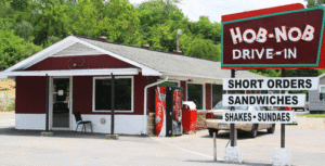
Hob Nob Drive-in Restaurant
This railroad yard and the community that surrounds it is the only place in Virginia named after Daniel Boone. This is the original Daniel Boone Wilderness Trail, and Boone reportedly drank from a spring in this area. Today, this area is more famous as the home of the Hob Nob, an iconic restaurant that has been in the same family for more than 60 years. It is famous for its diner fare, in particular the soft-serve ice cream cones.
Clinchport, Virginia and Stock Creek
Cinchport was the head waters of flat boat navigation on the Cinch River, just as Kingsport was on the Holston. Not only did pioneer loggers build massive log rafts here in the winter to catch the spring tide to float their logs to mills at Chattanooga, but settlers farther up the Clinch would bring produce downstream in dug out canoes called bateaux. Clinchport was the region’s point of entry into the Tennessee River System. The Wilderness Road followed Stock Creek from here.
Natural Tunnel State Park, Duffield, Virginia
Natural Tunnel is a great spot to stop, get out and stretch your legs. Although the Visitor Center is not open to the public now, the chairlift down to the bottom of the Tunnel is currently available Friday through Sunday. Ride the chairlift down where you can take the boardwalk out to the mouth of the 850-feet long tunnel. Tall as a ten-story building, the limestone cave within the tunnel was carved out thousands of years ago by Stock Creek.
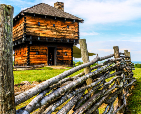
Replica of John Anderson Wilderness Road Blockhouse
Wilderness Road Blockhouse Exploration Station, Natural Tunnel State Park, Duffield, Virginia
Located within Natural Tunnel State Park, the Wilderness Road Blockhouse is a replica of the original John Anderson Blockhouse that stood on now Carter’s Valley Road and served as a gathering point for pioneers. Those making their way westward would gather at the Blockhouse until there were enough “guns” to make the trek through Indian territory westward to Kentucky. The Blockhouse is currently closed to visitors due to COVID-19, but travelers may still stop and walk around the grounds.
Daniel Boone Historical Marker, Duffield, Virginia
One of the few remaining Daniel Boone Historical markers in existence.
Kane Gap, Duffield, Virginia
This natural notch was a welcome sight to travelers on the Wilderness Trail. It was through this Gap that countless thousands trudged as they made their westward. Accessed via Fraley Avenue, Duffield, this is the only trail where you can actually walk in the footsteps of famed frontiersman Daniel Boone. The trail is part of the Daniel Boone Birding and Wildlife Trail. Managed by the Jefferson National Forest Service, the trail is moderate to difficult, but is worth the climb to the Gap. Just before reaching the Gap, visitors will see the “pioneer hotel” recorded in many journals. This large rock outcrop served as a shelter to the thousands before they crossed down into the valley below.
Daniel Boone Wilderness Road Interpretative Center, Duffield, Virginia
A satellite location of Natural Tunnel State Park, the Center is currently open Fri.-Sun., 10 a.m.-6 p.m. Admission is free. Here visitors learn the important role the Wilderness Road played in American’s westward expansion. The center offers a glimpse of the rough, unforgiving terrain early settlers traversed on their way to Kentucky. The museum focuses on the portion of the trail from Sycamore Shoals in Elizabethton, Tennessee to the Cumberland Gap and the brave men, women and children who traveled the trail. There are several hands-on exhibits, such as striking flint and steel to get a spark.
Powell Mountain Overlook, Duffield, Virginia
Regardless of the season, the Powell Mountain Overlook always delivers an amazing view. Located between Duffield and Stickleyville, Virginia, the Overlook offers a spectacular view down into the valley below and is a favorite stop along the Wilderness Road.
Stickleyville School, Stickleyville, Virginia
The school stands on or near the site of the massacre of James Boone, Daniel’s son. At the time, the Boones were migrating to Kentucky and James had gone ahead along with several others, notably, Henry Russell. According to accounts of the massacre, “wolves” howled all night around the camp. At dawn, a mixed party of Shawnee and Cherokee Indians attacked and shot James Boone and Henry Russell, through the hips so that they could not escape. The pair were then tortured with knives and then killed. Boone is said to have asked a Shawnee Indian, Big Jim, who Boone knew from visits to the Boone family homestead in North Carolina, to kill him. Russell was reportedly clubbed to death and his body shot full of arrows.
Jonesville, Virginia
Mumps Fort stood at the top of the hill where the current courthouse is located today. The Fort was built by William Mumps in 1775 in a community known then as Glade Spring or Sinking Springs. Mumps Fort abandoned in 1776 at the outbreak of the Cherokee War. The garrison was then repositioned at Fort Blackmore in Scott County, Virginia.
White Cliffs, Ewing, Virginia
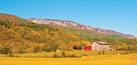
White Cliff Rocks, Ewing, Virginia
The white rock cliffs atop Cumberland Mountain were among the most commonly mentioned geographic features recorded in the journals of the emigrants along the entire length of the Trail. The pioneers seemed to take the cliffs as a hallmark of the wonderful new land that they were claiming as their own.
The term Cumberland seemed to ring in the souls of the pioneers as the name of the port-of-entry into the Promised Land. The Cumberland Mountain guided them on their way until they reached Cumberland Gap, which was the gateway to Eden. From there they traveled across the Cumberland Valley to the Bluegrass of Kentucky.
Wilderness Road State Park, Ewing, Virginia
The Wilderness Road State Park offers picnicking, hiking and nature, and living history programs. Visitors can enjoy the visitor center, home to a theater showing an award-winning docudrama, “Wilderness Road, Spirit of a Nation.” The center also has a frontier museum and a gift shop with unique regional gifts. The park features the reconstructed Martin’s Station, an outdoor, living history depicting life on Virginia’s 1775 frontier. Guests can also enjoy the park’s picnic shelters, nature play-scape, ADA-certified playground, sand volleyball court and horseshoe pits.
Visitors can hike, bike or horseback ride on the 8.5 Wilderness Road Trail linking the park with more than 50 miles in the Cumberland Gap National Historical Park.
Cumberland Gap National Historical Park, Middlesboro, Kentucky
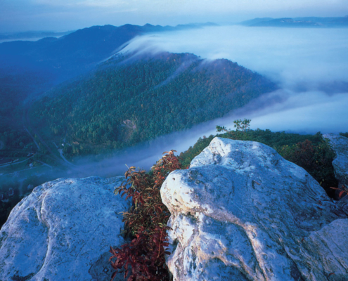
Cumberland Gap National Park
Cumberland Gap National Park is located at the crossroads of Kentucky, Tennessee and Virginia and creates a natural break in the Appalachian Mountains. The Cumberland Gap Visitor Center features a museum with interactive exhibits about the Gap’s role as a transportation corridor, and also features the Cumberland Crafts gift shop, which houses juried wares from crafters throughout Appalachia.
The park covers 24,000 acres and is among the largest national parks in the eastern United States. Stretching about 20 miles, the park runs along the Cumberland Mountains. It includes 24 known cave features, ranging in size from around 20 feet to more than 16 miles in length. There are also a large number of cliff systems in the park, the most prominent of which is the 500 feet cliffs of White Rocks, which is located in the eastern portion of the area. At the northeastern end, the park lies adjacent to the Sillalah Creek Wildlife Management Area and Martin’s Fork Wildlife Management Area and State Natural Area.
Driving the entire Wilderness Road Trail can be done in one full day. Conveniently located along the way are several places to dine, including Campus Drive-in and The Maple Tree Book Store and Coffee House, Gate City; the Hob Nob, Daniel Boone; ChuBeez, Duffield; A Better Burger, Jonesville; and Dutch Treat, Rose Hill; as well as national chain fast food restaurants.
For lodging convenient to the Wilderness Trail, visitors have the option of Roberts Mill Suites and Estilville Bed & Breakfast, Gate City; Appalachian Mountain Cabins and PapPaw’s Cabin, Duffield; and Wilderness Road Bed & Breakfast, Ewing. Camping is available at both Natural Tunnel State Park and Cumberland Gap Wilderness Road Campground.