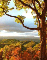
Chief Benge Scout Trail (CBST) is a good overnight backpacking opportunity or hike a section. Things to see and enjoy vary from High Knob overlook, cold mountain lakes, following streams in deep gorges, and Little Stony plunge waterfall.
How to get there
There are several routes to the High Knob Trailhead from Gate City, VA. One is direct for 25 miles on backroads in the Jefferson National Forest; another, is 40 miles but less than ten minutes longer due to better highway road. Choice depends on what you are doing and how much time available.
Better road route to High Knob:
- Take US23 north for 33 miles around to Norton, VA.
- Turn right/east on Hoot Owl Hollow Road/Route 622 for 1.5 miles.
- Turn right/south on Alley Valley Road for just under three miles.
- Turn sharp left/NE on FS Road 238 for half mile.
- Turn right/SW for short road to the former site of the High Knob Observation Tower.
Backroad route to High Knob:
- Take VA71 east out of Gate City for couple of miles.
- Turn left/north on VA72 for 11 miles to Ft. Blackmore.
- Turn left/north on Big Stoney Creek Road for 3.6 miles.
- Veer right/north to take Alley Valley Road/FS 213 for half mile, then first left to stay on Alley Valley Road for another winding 7.5 miles.
- Veer right/NE on FS Road 238 for half mile.
- Turn right/SW for short road to the former site of the High Knob Observation Tower.
Little Stony Creek Falls trailhead:
- Take VA71 east of Gate City for couple of miles.
- Turn left/north on VA72 and proceed north (through Ft. Blackmore and Dungannon, then past USFS Hanging Rock Recreation Area) for about 29 miles. The last road section will be very curvy.
- Turn left onto VA664 and go 1.1 miles
- Turn left onto gravel FS Road 700 and go 1.4 miles
- At the road split take the left (FS Road 701) and go 1 mile to gravel parking area.
For a car drop at Hanging Rock Rec. Area, then starting at High Knob:
- Take VA71 east of Gate City for couple of miles.
- Turn left/north on VA72 and proceed 22 miles north (through Ft. Blackmore and Dungannon) to USFS Hanging Rock Recreation Area.
- Drop off shuttle vehicle.
- Continue north on VA72 another eight miles to Norton, VA.
- Turn west on Highway US58 for nine miles to Exit #1.
- Take exit south onto Alley Valley Road/FS 213 for four miles.
- Turn sharp left/NE on FS Road 238 for half mile.
- Turn right/SW for short road to the former site of the High Knob Observation Tower.
- You’re now at High Knob to begin the trip.
Trailheads: Seven trailheads serve the Chief Benge Scout Trail:
High Knob Trailhead: Located off FS 238 at the former site of the High Knob Observation Tower. This is the westernmost point on the trail. To reach the trailhead, head north on Rte 619 from Ft. Blackmore. After 3.6 miles, you will need to make an abrupt right turn to remain on 619. The scenic gravel road heads straight up the side of High Knob for 14.9 miles past Ft. Blackmore before you turn right onto Rte 238. After 1.6 miles, turn right onto Rte 233. Follow Rte 233 to a parking area at the end.
High Knob Lake: This trailhead is gated in the winter (Sept. 15 – May 15.) During the summer, a parking fee applies. To reach the trailhead, head north on Rte 619 from Ft. Blackmore. After 3.6 miles, you will need to make an abrupt right turn to remain on 619. The scenic gravel road heads straight up the side of High Knob for 14.9 miles past Ft. Blackmore before you turn right onto Rte 238. Follow Rte 238 for 1.6 miles to the campground entrance. Turn right onto the campground road and follow it for 1.7 miles to the parking lot at the end.
 Mountain Fork: This is not an official trailhead, merely a pull off on the road. To reach Mountain Fork, head north on Rte 619 from Ft. Blackmore. After 3.6 miles, you will need to make an abrupt right turn to remain on 619. The scenic gravel road heads straight up the side of High Knob for 10 miles past Ft. Blackmore before you turn right onto Rte 704. Follow 704 for 3 miles until you see a pull off where the road crosses a creek. Rte 704 is locked in the winter from Sept. 15 – May 15.
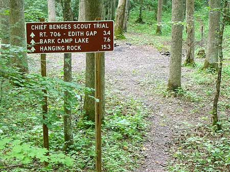
Edith Gap: This is not an official trailhead, merely a pull off on the road. To reach Edith Gap, head north on Rte 72 from Dungannon for 8.4 miles. Turn left onto Jaybird Branch Rd. and follow it for 3.2 miles. Take a slight left onto Pine Camp Rd. and drive for 2.6 miles. Turn left at Robinson Knob Rd. and drive for 1.2 miles. (You will need to take a second left to stay on Robinson Knob Rd.) Turn left onto Edith Gap Road and drive for about 0.9 miles (taking a second left to stay on Edith Gap Rd.) Stop at a pull off.
Bark Camp Lake: This trailhead is gated in the winter (from mid Oct. – April 1.) During the summer, a parking fee applies. From Dungannon, follow Rte 72 north for 0.4 miles, then turn left onto Rte 653. After 1.7 miles on Rte 653, turn right onto Rte 706. Follow Rte 706 for 2.7 miles, winding up onto the mountain, then take a sharp right onto Rte 822. You will need to take a couple of lefts to stay on Rte 822, following the road for 3.3 miles. Then turn left into the Bark Camp Lake entrance and travel 0.9 miles to the parking area.
Little Stony Falls: Little Stony Falls marks the official eastern end of the Chief Benge Scout Trail, but many hikers opt to tack on three more miles to view the falls and end up at the Hanging Rock Trailhead. To reach the Little Stony Falls trailhead from Dungannon, follow Rte 72 north for 7.7 miles, then turn left onto Retford Rd (Rte 664.) After 0.4 miles, take a slight left at Corder Town Rd/Quartertown Rd. Follow Corder Town Rd. for 0.8 miles, then turn left onto Forest Road (Rte 700). Follow Forest Rd. for 1.3 miles, then take a slight left onto Rte 701. The trailhead is at the end of the road. During the winter, Rte 700 is locked.
Hanging Rock Trailhead: Take Rte 72 north out of Dungannon toward Coeburn for 2.6 miles. Turn left at a large sign into the Hanging Rock Recreation Area at a hairpin curve. During the winter, the Forest Service locks the gate to the Hanging Rock Recreation Area a quarter mile from the usual parking area.
Facilities:
High Knob Lake — campground, restrooms, drinking water, sandy beach in a 4 acre, cold water lake
Bark Camp Lake — campground, restrooms, drinking water, boat launch, picnic areas, 45 acre lake
Hanging Rock Trailhead — restrooms, picnic areas, drinking water