36-Miles of Historic Virginia Coal Heritage Trail in Scott County, Virginia
Scott County was formed in 1814 out of Lee, Russell, and Washington Counties.
The county plays host to a variety of natural and cultural attractions. The Daniel Boone Wilderness Trail travels through Scott County and witnessed thousands of pioneers pass through on journey as part of our nations westward expansion. The Coal Heritage Trail travels along Route 23 from Lee County 4.09 miles to the town of Duffield, Virginia. Duffield, once known as Little Flat Lick, serves as a gateway to the West along the Wilderness Road. This location provides a vantage point in which visitors can watch the trains roll past full of coal leaving Southwest Virginia.
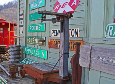 Located on the right at the intersection of Route 58/421/23 is the Fannon Railroad Museum operated by local railroad enthusiast Kenny Fannon. Many of the exhibits and items on display depict the rich railroad history that was a result of the coalfields that lay just to the North.
Located on the right at the intersection of Route 58/421/23 is the Fannon Railroad Museum operated by local railroad enthusiast Kenny Fannon. Many of the exhibits and items on display depict the rich railroad history that was a result of the coalfields that lay just to the North.
The Coal Heritage Trail leaves Duffield and travels 4.6 miles on Rt. 871 (Natural Tunnel Parkway) to Natural Tunnel State Park.Natural Tunnel State Park
The 850 foot long Natural Tunnel provides a way through to the coalfields beginning in 1890 and continuing until today. The tunnel is the focal point of Natural Tunnel State Park. The park offers a variety of recreational activities.
The Coal Heritage Trail then leaves Natural Tunnel State Park along Rt. 871 and travels 1.2 miles to an intersection with Route 23/58/421. Turning left onto Route 23/58/421, travel 1.26 miles to Route 65 (Clinch River Highway).
After turning left onto Route 65, you will travel under the Norfolk Southern Railroad trestle. This trestle represents one of two major railway lines hauling coal out of Southwest Virginia to Southeastern U.S. power plants.
The Coal Heritage Trail then leaves Natural Tunnel State Park along Rt. 871 and travels 1.2 miles to an intersection with Route 23/58/421. Turning left onto Route 23/58/421, travel 1.26 miles to Route 65 (Clinch River Highway).
After turning left onto Route 65, you will travel under the Norfolk Southern Railroad trestle. This trestle represents one of two major railway lines hauling coal out of Southwest ie
Virginia to Southeastern U.S. power plants.
The area immediately past the railroad trestle is what remains of a town known as Clinchport. This once thriving river town was completely destroyed by a catastrophic flood in 1977. Remains of the town blocks can still be seen.
From Clinchport, you will travel 8.6 miles to the town of Ft. Blackmore. Along the way you will be traveling parallel to the Clinch River, one of the most ecological diverse rivers in the 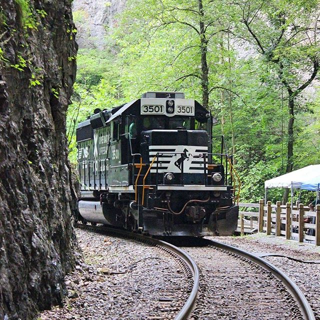 United States. The Clinch River flows 135 miles through Southwest Virginia and into Tennessee where it ends at the Tennessee River. Also following the river is the CSX railroad formally known as the Carolina, Clinchfield, and Ohio Railroad. This railroad, in addition to the aforementioned Norfolk Southern line, provided avenues of commerce through Scott County to move coal, timber, and freight products from the region.
United States. The Clinch River flows 135 miles through Southwest Virginia and into Tennessee where it ends at the Tennessee River. Also following the river is the CSX railroad formally known as the Carolina, Clinchfield, and Ohio Railroad. This railroad, in addition to the aforementioned Norfolk Southern line, provided avenues of commerce through Scott County to move coal, timber, and freight products from the region.
While traveling along Route 65 you will pass the General John Salling Monument. This monument is in honor of General John Salling, Virginia’s last surviving Confederate veteran and resident of Scott County. General Salling died in March of 1959 at the age of 112.
Upon arriving at Fort Blackmore, you will turn left on State Route 65/72 and travel 8.35 miles to Dungannon, Virginia. Fort Blackmore was a famous early fort and was situated on an ancient elevated flood plain on the north side of the Clinch River. For many years, this fort was on the extreme frontier of Virginia and was used by hunters, explorers, adventurers, and home seekers for rest and refreshment. Daniel Boone was in command of Fort Blackmore and other forts on the Clinch River in 1774 while the militiamen were engaged in the Point Pleasant campaign of Dunmore’s war. From Ft. Blackmore continue on Rt. 65/72, 8.35 miles to the town of Dungannon.
In Dungannon, be careful to turn right on Rt. 65 and cross the Clinch River following Route 65 as it travels 5.08 miles to the Russell County line. In Dungannon, Route 72 leaves Route 65 and travels up the mountain to Coeburn, Virginia where you can continue on the Coal Heritage Trail in Wise County, Virginia.